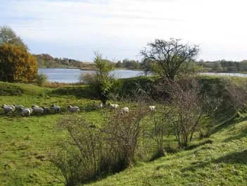
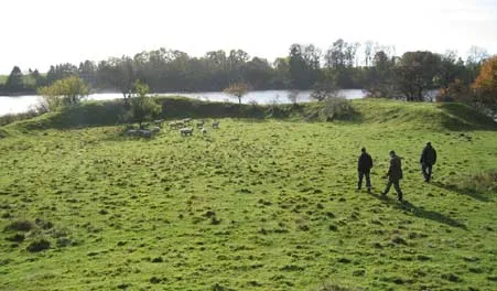
In reality, the earthworks are part of a smaller fortification, most likely from the Iron Age.
The earthworks have been dated by archaeologists to be older than the Middle Ages. Researchers have previously speculated that the site was either a people's fort for protecting the local population during turbulent times, or that it had a religious purpose related to sacrifices. The shape of the site and the lake's former name, Valsø, meaning "lake of the dead," could suggest this.
So, what are the mounds?
Recent research, however, has proposed a different explanation. The last Ice Age left behind a tunnel valley with wetlands, stretching all the way from Køge over Kværkeby Mose to Vigersdal. The lakes, including Haraldsted and Gyrstinge lakes, are the deepest parts of the wetland, but the areas between the lakes were marshy and swampy. The streams were significantly more water-filled than they are today. This made it possible to sail between the towns on Zealand, but also made land travel difficult, so people had to use the relatively dry crossing points that existed.
At Værkevad (or Virkevad, as it has also been written) east of Haraldsted Lake, there was a crossing point. The lake extended further east at that time. From the Riding Arena, there was a good view of the lake and the crossing point, allowing control of traffic, both on land and on water. The name also suggests a military site: ‘virke’ means fortification. The earthworks likely gave the crossing point its name.
The second crossing point was at the other end of Haraldsted Lake, between Haraldsted and Gyrstinge lakes. Here lie the ruins of Gørlevsborg or Gørrildsborg, as it is also called. From here, the western crossing point could be monitored.
What did it look like?
The earthworks were at least 4.5 meters higher than the external ground level we see today. When the National Museum investigated the site about 100 years ago, it appeared that the top of the earthworks was designed to support a parapet. Later excavations have shown that the water reached all the way up to the earthworks on the lake side.
Inside the earthworks, there was an elliptical area about 50m x 80m in size. Although this gives 3,000 m², it is probably not large enough for an entire population to seek protection here for an extended period, but there was enough space for a group of soldiers on guard.
The access to the site behind the earthworks was via a sunken road, which was probably reinforced with stones and hidden from view by dense forest. There was also access from the lakeside, likely through a palisade defense.
The theory of a religious site
Measurements of the earthworks show that the site is very symmetrical; parts of the site take the form of a parabola, oriented almost exactly north-south. The access road opened up in a funnel shape towards the area formed by the earthworks. It is also interesting that the centerline of the funnel-shaped opening points towards the focal point of the parabola created by the earthworks. The top of the earthworks was originally almost horizontal. Furthermore, a three-part division of the earthworks can be seen, which may be reminiscent of the sacred number 3. In the North, we had the 'trinity of gods' Odin, Thor, and Freyja.
It has not been possible to verify whether the theory of a religious site is the explanation for the design of the site.
Valsøgård has belonged to Anne Meinstrup
Today, only faint traces of the fortification that once stood immediately west of the knight's mounds can be seen. The history of Valsøgård dates back to the 14th century. One of the most famous owners of Valsøgård was Anne Meinstrup. She was, in the early 1500s, one of the most influential women in the country as a court lady. During the civil war known as the Count's Feud, she was murdered during a meeting at the Thing in Ringsted in 1535. Valsøgård was plundered and burned. Anne Meinstrup’s daughter rebuilt Valsøgård. It remained in the family’s possession until 1573, when it was transferred to the crown in a land exchange. By the early 1600s, Valsøgård was so dilapidated that it was either demolished or converted into a smaller property. Originally, Valsøgård consisted of two wing buildings in a right angle, surrounded by moats on three sides. Later, a southern wing and an outer moat were added, so after the plundering during the Count's Feud, the castle was protected by both inner and outer moats. The outer moat is still filled with water today.
During excavations in 1917, various building parts were found on the site. These included a floor of Öland stone, glazed tiles, and ornately carved sandstone, which may have framed windows in the Renaissance castle, as well as roof tiles.
Access to the site
When visiting the area, you must take into account that it is private property:
- Access to the Riding Arena and the Fortification site is as shown on the map in the brochure "Ridebanen and Valsøgård." Follow the grass embankment from the barn and head towards the area. Do not walk in the cultivated fields on either side of the embankment.
- Access is permitted year-round from 6:00 AM to sunset. Camping is not allowed.
- Keep the gate closed so the sheep do not escape.
- You may only walk; bicycles are not allowed.
- Open fires and littering are prohibited.
- Parking is available in the road shoulder along Valsømaglevej. Please avoid parking in the driveway to the farm.
Owner: Ringsted Municipality
